Visualizing the Geospatiotemporal Spread of the Pandemic
Displaying COVID-19 deaths per country per day on a rotating 3D Earth.
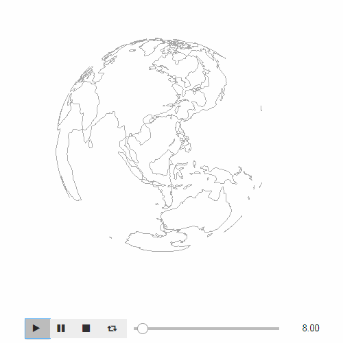
An animation displays on a 3D Earth the total number of deaths for each day. They are represented in log scale as cones positionned on capital's locations of each country. During the animation, the 3D Earth is rotating around its own axis eastward to enable the user to see the spread of the pandemic. The speed of the rotation is not related to the speed of Earth's rotation.
The outcome figure itself intends to look like the coronavirus as a sphere with spikes.
Data sources:
- COVID data per country + ISO 3 codes and per day from Our World in Data, see: https://ourworldindata.org/coronavirus-source-data
- Countries + ISO 2 and 3 codes from GeoNames, see: https://www.geonames.org/countries/
- Capitals + ISO 2 codes and latitude + longitude from GeoNames, see: http://download.geonames.org/export/dump/
- Coastlines shape file from Natural Earth, see: https://www.naturalearthdata.com/downloads/110m-physical-vectors/
Limitations of the data visualization:
- For large countries like China or the USA, displaying data per region would be more meaningful instead of data for the whole country and positionned on capital's location, provided data are available.
- The displayed 3D Earth uses a pure spherical model, it is not the actual shape of the Earth.
- The displayed 3D Earth is transparent, it might be opacified slightly to ease the interpretation of the graphic.
- The animation widget displays the number of days since the pandemic started, it might be switched to the actual date of the data.
Author: Francis Wolinski
0. Import libraries
The visualization relies on a few Python libraries.
# imports
import numpy as np
import pandas as pd
import ipyvolume as ipv
import shapefile
import pythreejs
# version of the used modules
for m in [np, pd, ipv, shapefile, pythreejs]:
    try:
        print(m.__name__, m.__version__)
    except AttributeError:
        print(m.__name__, m._version.__version__)
# load COVID data for 2020
df_covid = pd.read_csv('data/owid-covid-data.csv')
df_covid = df_covid.loc[df_covid['date'].str.startswith('2020')]
df_covid.head(3)
1.2 Country data with ISO 2 and 3 codes
# load country data with ISO 2 and 3 codes
var = pd.read_html('data/geonames.htm')
df_countries = var[1]
df_countries = df_countries[['ISO-3166alpha2', 'ISO-3166alpha3', 'Country']]
df_countries.head(3)
1.3 Capital data with longitude and latitude
# load city data with longitude and latitude of capitals (type == 'PPLC')
df_capitals = pd.read_csv('data/cities15000.txt',
                        sep='\t',
                        header=None,
                        usecols=[4, 5, 7, 8],
                        names=['lat', 'long', 'type', 'ISO-3166alpha2'])
df_capitals = df_capitals.loc[df_capitals['type'] == 'PPLC']
df_capitals.head(3)
1.4 Shape file with coastlines
# load shape file with coastlines
sf = shapefile.Reader('ne_110m_coastline/ne_110m_coastline.shp')
2. Data integration and transformation
# This function adds to a DataFrame 3D point coordinates
# computed from longitude and latitude in degrees.
# It relies on a spherical model which simplifies the actual shape of the Earth.
# It also perfoms a permutation between axis (x -> -x, y -> z, z -> y)
# Used for capitals as well as coastlines

degres_to_radians = np.pi / 180.0

def compute_xyz(df):
    long_in_radians = df['long'] * degres_to_radians
    lat_in_radians = df['lat'] * degres_to_radians
    df['x'] = - np.cos(long_in_radians) * np.cos(lat_in_radians)
    df['y'] = np.sin(lat_in_radians)
    df['z'] = np.sin(long_in_radians) * np.cos(lat_in_radians)
2.1 Merge countries and capitals
# merge countries and capitals using ISO 2 codes
df_geo = pd.merge(df_countries,
                  df_capitals,
                  on='ISO-3166alpha2',
                  how='inner')
df_geo.head(3)
2.2 Compute a table with total deaths (log scale) by country and by day
# table with total deaths by country and day
col = 'total_deaths'
df_pandemic = df_covid.pivot_table(index='iso_code',
                                   columns='date',
                                   values=col)
df_pandemic = df_pandemic.fillna(0).astype(int)
df_pandemic = df_pandemic.fillna(1.0).clip(1.0, None).apply(np.log)
df_pandemic.head(3)
2.3 Merge the total deaths table and the geo data
The final DataFrame contains one column per day (from 2020-01-01 to 2020-05-31) with the total deaths per country and the appropriate 3D positions of the capital of each country.
# merge total deaths and geo data using ISO 3 codes
df_pandemic = pd.merge(df_pandemic.reset_index(),
                       df_geo,
                       left_on='iso_code',
                       right_on='ISO-3166alpha3',
                       how='inner')
compute_xyz(df_pandemic)
df_pandemic.head(3)
3. The final figure
The final figure is plotted in few steps:
- Plot the total deaths per day in darkred arrows which heights represent the total deaths in log scale. The size argument is used by the animation.
- Plot the coastlines by transforming the lists of longitudes and latitudes of each point in 3D point coordinates by reusing the compute_xyz() function.
- Set up the animation.
- Set up the automatic rotation of the 3D Earth.
# plot the figure
fig = ipv.figure()

# total deaths data are in columns whose name starts with '2020'
cols = [col for col in df_pandemic.columns if col.startswith('2020')]

# plot the total deaths (log scale) as red arrows around the 3D Earth
# all data are fixed except the size which will change at each step
xs = df_pandemic['x'].values
ys = df_pandemic['y'].values
zs = df_pandemic['z'].values
s = ipv.scatter(xs * 1.05, ys * 1.05, zs * 1.05,  # factor to move the arrow out of the 3D Earth
                vx=xs, vy=ys, vz=zs,
                size=df_pandemic[cols].T,
                color='darkred', marker="arrow")

# plot the coastlines
for shape in sf.shapes():
    df = pd.DataFrame(shape.points, columns=['long', 'lat'])
    compute_xyz(df)
    xs = df['x'].values
    ys = df['y'].values
    zs = df['z'].values
    ipv.pylab.plot(xs, ys, zs, color='darkgrey')

# display parameters
ipv.xyzlim(1)
ipv.style.use('minimal')
animation_control = ipv.animation_control(s, interval=200, sequence_length=len(cols))
ipv.show()

# control parameters
control = pythreejs.OrbitControls(controlling=fig.camera)
fig.controls = control
control.rotateSpeed = 0.07
control.autoRotate = True
fig.render_continuous = True
The animated GIF file has been produced thanks to the LICEcap software, see: https://www.cockos.com/licecap/